National Park Hiking Adventures - Olympic
- Lamar Shahbazian
- May 26
- 9 min read
To call this a hiking adventure trip is a little ambitious, but we did take some nice "walks". That's what we get for traveling to parks in the Northern US in what some still consider "winter" conditions. In fact, Mount Rainier National Park was still closed so we couldn't get in to see that one at all!

One of the first things we do when we visit national parks is stop at the Visitor Center. I have a whole new appreciation for these after not having access to them for our last trip to South Dakota (the federal government shutdown had closed all these centers). Looking back, the process we used of taking photos of the different attractions in the park in the Visitor's Center, making preliminary decisions and then checking back during our trip, worked out perfectly.
One of the things we had neglected to do prior to visiting was check the tide schedule. It’s not often that we have visited national parks with an ocean component, but we’ll add that to our trip prep in the future. Several of the ocean-side attractions were most interesting during low tide, which was not going to happen at a convenient time for our trip. Bummer! You can literally see the Visitor Center learning in my photo sequence. I took photos of the monitor where they advertised park adventures and then recorded the tide table (taking a photo). I then went back to the monitor and added the Rain Forest info as we now had time to spend a day there since our beach adventures would be limited.
Rick also downloaded the National Park Service app because we started reading about the road closures and decided we needed to keep up to date with that as well. It's so nice that all these resources are available. And most are free!

Our first stop in the park was Hurricane Ridge, as we hoped to do a simple hike there. In case you're wondering where the name came from, here's what Google has to say:
Early visitors and prospectors in the late 1890s experienced extreme weather systems sweeping off the Strait of Juan de Fuca, with gusts routinely exceeding 75 mph. Because of these gale-force winds, the name "Hurricane" was adopted."
As we drove higher and higher, I was watching the snowline on the surrounding mountains, and noticed that we were at the same approximate elevation, so I was getting worried about our ability to hike. They had nicely cleared the parking lot and most of the top of the mountain so you could walk around and see the views. But the hiking trail was not cleared of snow, so we took some photos and drove back down. Pretty photos though! And I had to take a picture of the woman knitting while she waited for her husband who was wandering around taking photos. That seems like something I might do!


I also took a photo of the sign in the (unattended) ranger trailer, which listed the surrounding peaks. It's too bad it didn't turn out better as it was hard to read with the reflection. They should sell postcards of this!
On a side note, I must find an app in which mountain peaks can be identified. I've tried using Google Maps and searching on "peaks", and that sometimes works, but we don't always have cell service. Hah! As often happens, now that I have more time and cell service, I found an app called "Peak Finder" and downloaded it for $4.99. The hikers in my family might know of something better, but I'll give this one a try. Before we leave Hurricane Ridge, here's the panoramic shot of all those beautiful mountains.

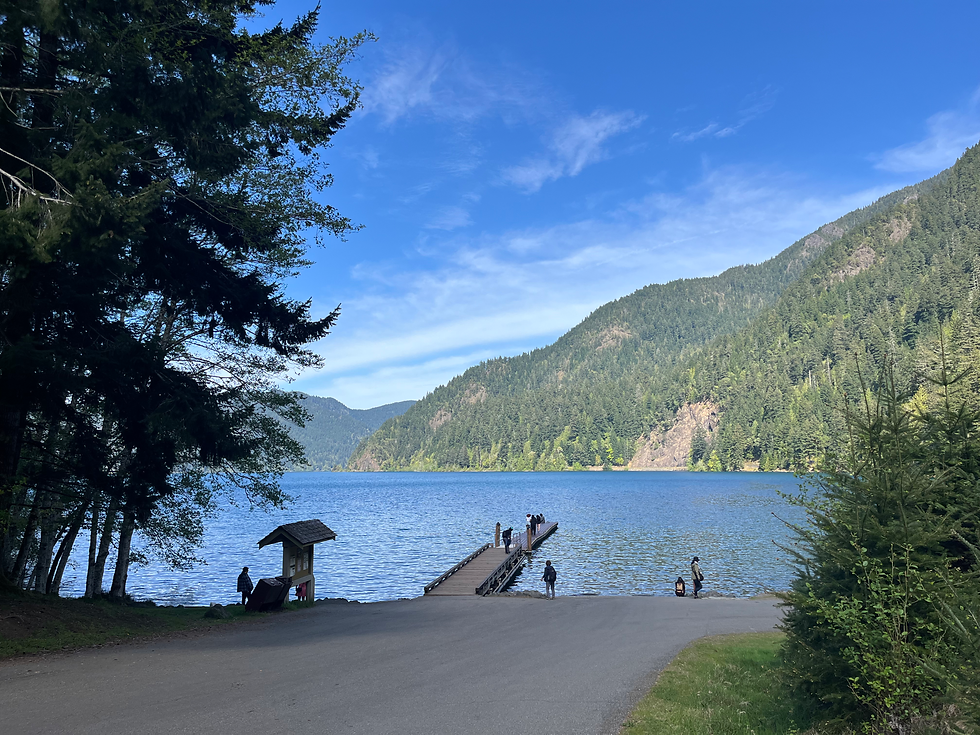
Since we still had time in our day, we looked back at our Visitor Center photos and decided to drive to Lake Crescent and see about hiking up to Marymere Falls. It's been awhile since we hiked, so we were a bit worried about tackling too much elevation, but this seemed doable.
The lake itself was quite pretty, and if the weather had been warmer we might have been tempted to enjoy its waters, but instead we tackled the hike right away. As always, there are unexpected delights along the way, like the clear-running water, the wildlife, and the wildflowers.


Toward the end, there was a one lane bridge crossing the creek, so I'm glad we were there mid-week as I bet that created a roadblock in high season. In case you haven't seen a clear-running stream lately, here's a video.
Then the steps began, which was our elevation for the hike. It's interesting, at the end there was a loop, and while the sign said to turn left, we could have gone in either direction. But I figured that if we went the direction of the sign, we'd be less likely to run into people coming the other direction, which is always awkward on a narrow trail. It turned out to be the best decision, though! The left section of the trail had steps, so it made the elevation very doable. There was a good view of the waterfall and people taking photos, so we enjoyed that.
But then we noticed that there were more steps up to a higher vantage point, and decided to take that leg. There was only one woman there, and she was distracted by a phone call so I took a photo of the little chipmunk that was taking advantage of her distraction.

The path down was loose gravel with no stairs. Another pair of hikers was huffing and puffing their way UP that side. So between the stairs, the fact that you could get a good view without tackling the added elevation, and the loose gravel we definitely took the better route! It was cute, all the way back down the trail Rick was telling people "Go left", trying to pass along our experience in real time!
After that, we decided to check into our hotel, which was in Port Angeles that night. It was a really nice lodge with a huge lobby. I bet it is really cozy in the winter with the fireplace going. We saw people sitting on the patio behind the lobby enjoying the view of the golf course and some snacks. Since they didn't have food available there, we went hunting for dinner. And now I was in the mood for a glass of wine! As one does, we rested in the hotel room and searched out some dinner options. We decided to try a place called Rosie's. They advertised having live music, so we were a bit worried about that since we thought it might loud or rowdy, but I'm so glad we went! It was on the top floor of a building right next to the wharf where the ferries come in from Canada, so areas of it were quite touristy. But this place had a bar where you placed your food order then a few minutes later, a cook would bring the food out. There was a family of young people taking the big table and an older couple at the table next to us.

The man who was going to play music seemed to know them so they were chatting in a friendly manner. More and more people came in as we got closer to 7 p.m. when live music was advertised to start. In the meantime, we enjoyed our drinks and received our food. I had an amazing salad and Rick had a delicious pizza, so we shared food and listened to the music. It seemed like there were lots of locals and they all knew each other. The music was very low-key, mostly 60s classics or earlier, so it suited the audience well. Such a fun place!
Being in a tourist area has advantages, such as this ice cream place that was downstairs from Rosie's. Normally we wouldn't have a milkshake for dessert, but when they had blackberry on the menu (Rick's favorite), we couldn't resist! And after all, it was our wedding anniversary the next day.

The following morning we checked out of our hotel and headed for the beach. Our destination was a town called "La Push", which we knew little about. We spent a half day or so exploring the town and First Beach, and then came back to the River's End Restaurant for our anniversary dinner. Unfortunately, we really never saw as much of this part of the national park as we had hoped due to high tides and heavy cold fog. I went looking for more info and found this blog, so if you want to know more about that area I recommend reading it.
The town of La Push itself was very small, and while I knew there is abundant Native American history here, I hadn’t realized that the whole town is situated on a reservation. Some of it was obvious, from the very new-looking school we passed as we approached the town to the police force. We parked at the beach right there in town, but found out that they had implemented a new “pay to park” system and it was, to our chagrin, the first day. They had a sign with a QR code, but unfortunately NONE of us had cell service so that wasn’t very helpful. They had an option to pay at the store (named but no directions), so we eventually found our way back there so we could pay and avoid a parking citation. I’m not sure any of the other visitors did so.


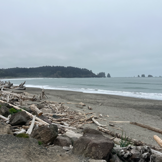


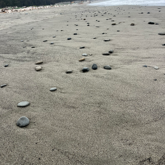


The beach itself was pretty, and unusual in that it contained a LOT of very large driftwood logs. This made an opportunity for many photos by itself. There were also “sea stacks” (a new term I learned on this trip), but other than that not much to look at. There were some other interesting sites that were available during low tide, so I don’t want to discount the potential experience, but between the weather and the lack of beach access, we weren’t too inclined to spend more time here.
That afternoon we traveled to a new hotel, a “river resort” near the town of Forks. We were a bit early, so it was awkward because the room was available but they had a painter working outside the rooms and he wasn’t going to be done until the “normal” arrival time. But the young woman who greeted us offered to move chairs from the porch to the lawn, and we spent an enjoyable 1.5 hours sitting in the sun, watching the river, and (for me) having a snack and reading. Rick kept an eye on the fisherman with a boat on the river. Alas, no fish for them that day. We were treated later to the sight of bald eagles perched on the tall trees across the river most likely, hunting.


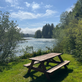

This place was clearly old, but had been updated and was very nice. There was a full kitchen, two bedrooms, a porch with comfortable seating, and beautiful gardens surrounded by forest. There were six suites with one occupied by a group of fisherman who departed on their fishing trip before dawn (as we heard since our bedroom window bordered the parking lot). Other than that brief interruption of sleep, it was a quiet, restful place.
The next day we decided to go on a couple of hikes in the Hoh Rain Forest (approximately 50 miles south), based on our Visitor Center introduction and later research. You would not think a hike called “Hall of the Mosses” would be very interesting, but it was! Things I particularly enjoyed were the waters surrounding the lower areas; the different types of trees and mosses; and the fabulous signage that was very educational.

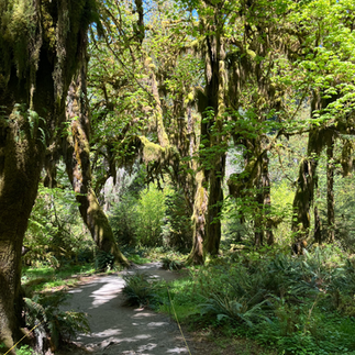


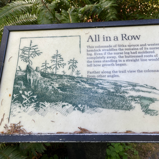
Our second hike, “Spruce Nature Trail” was very close to the first, so we did both. That one was not as pretty, but we could have taken a detour to the river since it bordered the hike. We also heard elk sounding off in the distance and I was happy that we didn’t run across any. The most interesting fact I learned on this hike was about “nurse logs”. I remembered vaguely learning about these in my Armstrong Woods hike , but we saw many examples on this hike. Some were from “Hall of the Mosses”, which had baby trees growing on a visible log, but my favorite was the nurse log on the Spruce hike. It was mostly visible because the trees all grew in a line, the original log was barely visible because it had mostly decayed. I am so glad the signage called our attention to this!


One last stop in this part of the park was to Ruby Beach. It was a quick hike down to the beach, which was picturesque enough that we saw both a bride and groom and a graduate getting photos taken. Again, due to cold, windy weather we didn't stay long, but it was definitely worth the stop! Stay tuned for the next leg of our trip to Issaquah and Snoqualmie Falls.


Great travel blog photos and videos. I laughed at the pay to park situation, but you're only left with a QR code and in a no-cell service area. Been there. Done that. And it's typically when I'm on vacation. Whhhhyyyyy??? LOL